
South of Prospect Neighborhood Plan
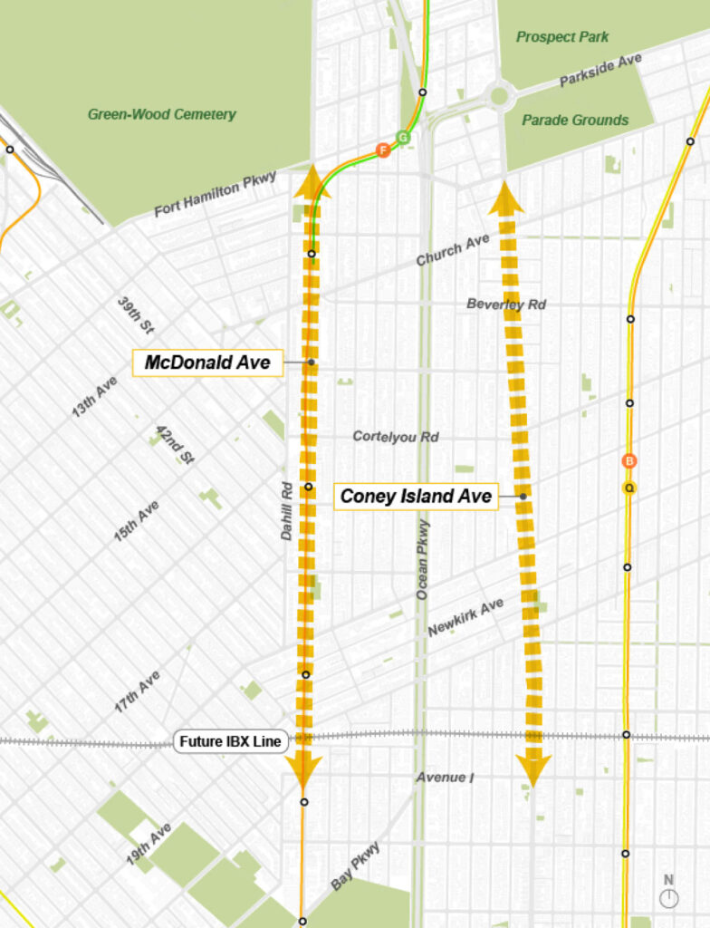
The planning area focuses on parts of Coney Island Avenue and McDonald Avenue. The plan will consider opportunities to:
- Create more housing near public transportation, including permanently affordable housing
- Support local businesses and expand economic opportunities
- Improve streets, sidewalks, public spaces, and other community resources
he New York City Department of City Planning (DCP) is working with Brooklyn community members and Council Members Rita Joseph, Shahana Hanif, Farah Louis, and Simcha Felder to develop a comprehensive plan for neighborhoods south of Prospect Park.
What Is a Neighborhood Plan, and How Is It Developed?
Fill out the survey
Take the South of Prospect Park survey to share experiences, ideas, and priorities for the future of the area. Visit the project website to access the survey in Spanish / español, Bangla / বাংলা, Urdu / اُردُو, Yiddish / ייִדיש, and Haitian Creole / kreyòl ayisyen.
CB14 Meetings
August 11, 2026 Meeting
Watch the meeting here or on CB14’s YouTube channel.
(The video below may take a few seconds to load)
July 16, 2026 Meeting
Watch the meeting here or on CB14’s YouTube channel.
(The video below may take a few seconds to load)
Background
How the Area Developed
The neighborhoods south of Prospect Park were once located along the borders of three Dutch towns: Flatbush, New Utrecht, and Gravesend. Through the early 1800s, the area was mostly rural, with large farms and scattered farmhouses.
The arrival of streetcars and trains led to rapid development and population growth. Coney Island Avenue, Ocean Parkway, and McDonald Avenue became major north-south routes through Brooklyn. By the 1920s, new apartment buildings, rowhouses, and one- and two-family homes were attracting residents from across the city. Commercial corridors also developed, with shops, theaters, and restaurants serving the growing neighborhoods.
After World War II, streetcar lines were replaced by buses and private cars. The area also continued to grow and change.
Orthodox Jewish families sought homes with space for larger households. A growing network of synagogues, yeshivas, and kosher businesses helped Borough Park become one of the largest Orthodox Jewish communities in the country.
Beginning in the 1980s, the area also became a center for Brooklyn’s South Asian community. Bangladeshi and Pakistani immigrants established communities in Kensington, supported by houses of worship and local organizations that connected new residents with jobs, housing, and cultural life. Over time, parts of Coney Island and McDonald Avenues became known as “Little Pakistan” and “Little Bangladesh,” with South Asian restaurants, stores, and social service organizations.
Zoning and Development
New York City adopted a new zoning code in 1961. The code preserved the lower-density character of neighborhoods such as Victorian Flatbush, while allowing modern elevator apartment buildings along Ocean Parkway. Coney Island and McDonald Avenues were designated for commercial uses focused on cars and trucks.
In 1977, the City created the Special Ocean Parkway District to further limit the size of community facilities and housing along Ocean Parkway. The district was expanded in 1993 to include 140 full and partial blocks on nearby side streets.
Beginning in the 1980s, contextual zoning districts were established in Park Slope and Windsor Terrace to manage building size, preserve neighborhood character, and encourage investment in existing housing. These efforts expanded southward in the 1990s. Historic district designations, downzonings, and added Board of Standards and Appeals oversight allowed modest home expansions while limiting larger new developments.
In 2009, the City rezoned 180 blocks in Flatbush. The rezoning further limited new housing on side streets while allowing some new housing along major corridors. Voluntary Inclusionary Housing incentives were rarely used, and little affordable housing was built through the program.
Planning Process
DCP will develop the plan with input from residents who live and work in Kensington, Prospect Park South, Ditmas Park, Borough Park, Midwood, and nearby neighborhoods.
The process begins with an online survey about community experiences, concerns, and priorities. Beginning this summer, DCP will hold in-person engagement events and visioning sessions in partnership with local Council Members and other City agencies. The feedback collected through these activities will help identify community priorities, challenges, and opportunities and guide the development of a shared vision for the area.
Take the South of Prospect Park survey to share experiences, ideas, and priorities for the future of the area. Visit the project website to access the survey in Spanish / español, Bangla / বাংলা, Urdu / اُردُو, Yiddish / ייִדיש, and Haitian Creole / kreyòl ayisyen.
Sign up for the DCP newsletter to receive updates about the planning process and upcoming community events.
Board Planning Resources
General
Statement of Community District Needs and Community Board Requests
CB14 Zoning, Planning, and Land Use Lunch and Learn Webinar Series
2009 Flatbush Rezoning
More resources coming soon
Community Environment, Cultural Affairs, and Economic Development Committee
Statement of Community District Needs and Community Board Requests
CB14 Planning Fellow Reports
Links
Social Housing Development:
Nonprofit Housing Developers
More resources coming soon
Community Safety Committee
Statement of Community District Needs and Community Board Requests
More resources coming soon
Housing and Land Use Committee
Statement of Community District Needs and Community Board Requests
CB14 Planning Fellow Reports
More resources coming soon
Human Services Committee
Statement of Community District Needs and Community Board Requests
More resources coming soon
Transportation Committee
Statement of Community District Needs and Community Board Requests
More resources coming soon
Youth Services, Education, and Libraries Committee
Statement of Community District Needs and Community Board Requests
More resources coming soon